Dosya:Arabia Armistice Mudros.png

Tam çözünürlük ((3.242 × 3.572 piksel, dosya boyutu: 1,12 MB, MIME tipi: image/png))
Bu dosya Wikimedia Commons'ta bulunmaktadır. Dosyanın açıklaması aşağıda gösterilmiştir. Commons, serbest/özgür telifli medya dosyalarının bulundurulduğu depodur. Siz de yardım edebilirsiniz. |
Özet
| Açıklama |
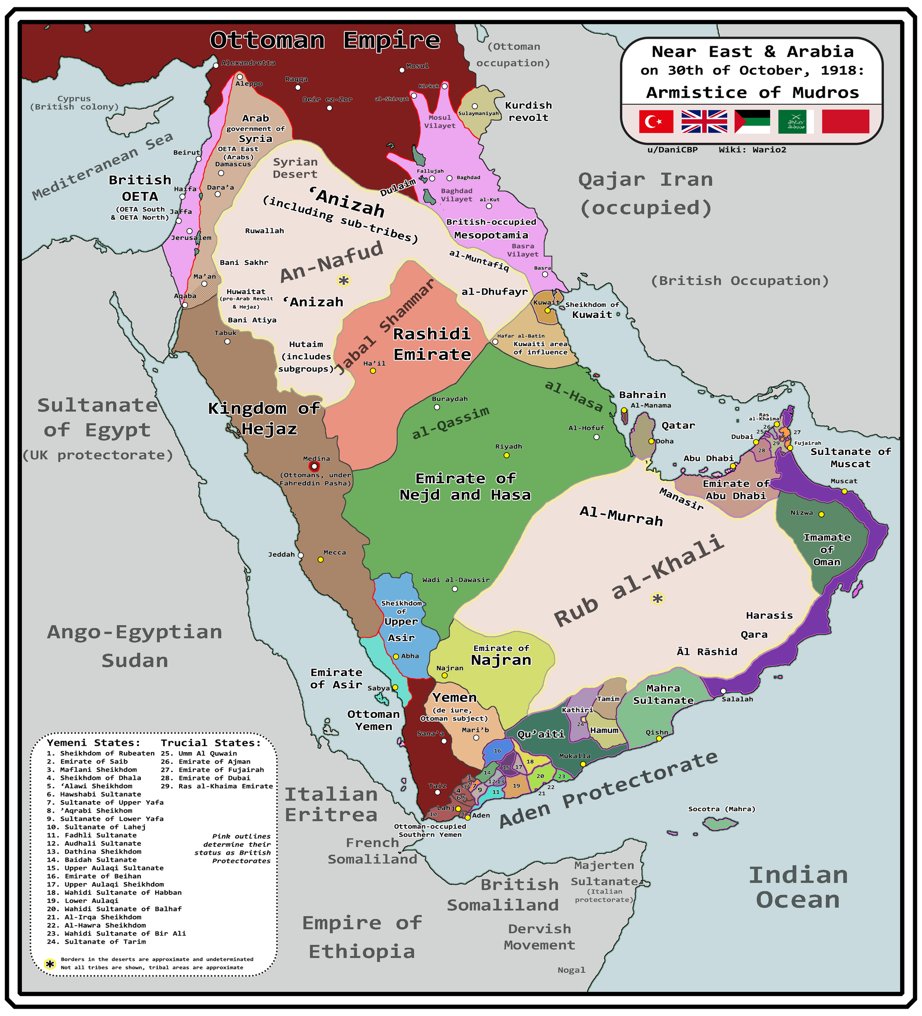
English: Map of Arabia and the Near East at the end of World War I, in October 30th, 1918, day of the Armistice of Mudros. |
| Tarih | |
| Kaynak |
Yükleyenin kendi çalışması + Ashkenazi, T. (1948). The ’Anazah Tribes. Southwestern Journal of Anthropology, 4(2), 222–239. http://www.jstor.org/stable/3628713 H. St. J. B. Philby. (1920). Southern Najd. The Geographical Journal, 55(3), 161–185. https://doi.org/10.2307/1781600 Haines, S. B. (1839). Memoir, to Accompany a Chart of the South Coast of Arabia from the Entrance of the Red Sea to Misenát, in 50° 43′ 25″ E. The Journal of the Royal Geographical Society of London, 9, 125–156. https://doi.org/10.2307/1797718 Helfritz, H. (1935). The First Crossing of Southwestern Arabia. Geographical Review, 25(3), 395–407. https://doi.org/10.2307/209308 Thomas, B. (1929). Among Some Unknown Tribes of South Arabia. The Journal of the Royal Anthropological Institute of Great Britain and Ireland, 59, 97–111. https://doi.org/10.2307/2843560 Anderson, S. (2014). Lawrence in Arabia: War, Deceit, Imperial Folly and the Making of the Modern Middle East. Atlantic Books Ltd. Boxberger, L. (2012). On the Edge of Empire: Hadhramawt, Emigration, and the Indian Ocean, 1880s–1930s. SUNY Press. J. E. Peterson. (1976) "The Revival of the Ibadi Imamate in Oman and the Threat to Muscat, 1913–20," Arabian Studies 3 Al-Maghafi, Fadhl (2012). "MORE THAN JUST A BOUNDARY DISPUTE: THE REGIONAL GEOPOLITICS OF SAUDI-YEMENI RELATIONS" (PDF). eprints.soas.ac.uk Bang, Anne (1997). The Idrisi State in Asir 1906–1934. Hurst Publishers. pp. 111–114. ISBN 9781850653066. Eskander, S. "Britain's Policy Towards The Kurdish Question, 1915-1923" (PDF). etheses.lse.ac.uk. |
| Yazar | Wario2 |
Lisanslama
- Şu seçeneklerde özgürsünüz:
- paylaşım – eser paylaşımı, dağıtımı ve iletimi
- içeriği değiştirip uyarlama – eser adaptasyonu
- Aşağıdaki koşullar geçerli olacaktır:
- atıf – Esere yazar veya lisans sahibi tarafından belirtilen (ancak sizi ya da eseri kullanımınızı desteklediklerini ileri sürmeyecek bir) şekilde atıfta bulunmalısınız.
Dosya geçmişi
Dosyanın herhangi bir zamandaki hâli için ilgili tarih/saat kısmına tıklayın.
| Tarih/Saat | Küçük resim | Boyutlar | Kullanıcı | Yorum | |
|---|---|---|---|---|---|
| güncel | 10.18, 13 Mart 2024 | | 3.242 × 3.572 (1,12 MB) | DaniCBP | Uploaded own work with UploadWizard |
Dosya kullanımı
Bu görüntü dosyasına bağlantısı olan sayfalar:
Küresel dosya kullanımı
Aşağıdaki diğer vikiler bu dosyayı kullanır:
- ar.wikipedia.org üzerinde kullanımı
- en.wikipedia.org üzerinde kullanımı
- es.wikipedia.org üzerinde kullanımı
- fr.wikipedia.org üzerinde kullanımı
- ko.wikipedia.org üzerinde kullanımı
- mt.wikipedia.org üzerinde kullanımı