Dosya:British map of Canton, 1840.jpg
Bu önizlemenin boyutu: 393 × 599 piksel. Diğer çözünürlükler: 157 × 240 piksel | 525 × 800 piksel.
Tam çözünürlük ((525 × 800 piksel, dosya boyutu: 153 KB, MIME tipi: image/jpeg))
Bu dosya Wikimedia Commons'ta bulunmaktadır. Dosyanın açıklaması aşağıda gösterilmiştir. Commons, serbest/özgür telifli medya dosyalarının bulundurulduğu depodur. Siz de yardım edebilirsiniz. |
Özet
| Açıklama |
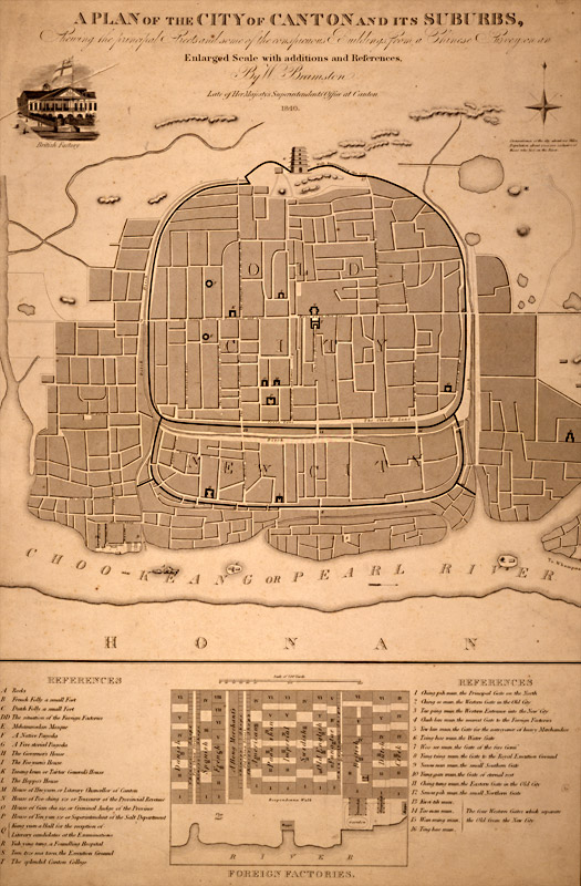
English: A plan of the city of Canton and its suburbs. REFERENCES A Rocks B French Folly a small Fort C Dutch Folly a small Fort DD The situation of the Foreign Factories E Mehammedan Mosque F A Native Pagoda G A Five-storied Pagoda H The Governor's House I The Foo-yuen's House]] K Tseang-keun or Tartar General's House L The Hoppo's House M House of Heo-yuen or Literary Chancellor of Canton N House of Poo-ching sze or Treasurer of the Provincial Revenue O House of Gan-cha sze or Criminal Judge of the Province P House of Yen yun sze or Superintendant of the Salt Department Q Kung yuen a Hall for the reception of Literary candidates at the Examinations R Yuh-ying-tang, a Foundling Hospital S Teen-tsze ma taou, the Execution Ground T The splendid Canton College |
| Tarih | |
| Kaynak | http://ocw.mit.edu/ans7870/21f/21f.027/rise_fall_canton_03/canton.html |
| Yazar | W. Bramston |
| Diğer sürümler |
|


Lisanslama
|
Bu çalışma ABD'de veya yazarın yaşamının sona ermiş olmasından 70 veya daha fazla süre geçtiğinde bu duruma uygun telif yasaları olan tüm ülkelerde kamu malıdır. | |
| Bu dosyanın, tüm ilgili ve komşu haklar da dâhil olmak üzere, telif hakkı yasası kapsamında bilinen kısıtlamalardan arınmış olduğu belirlendi. | |
Dosya geçmişi
Dosyanın herhangi bir zamandaki hâli için ilgili tarih/saat kısmına tıklayın.
| Tarih/Saat | Küçük resim | Boyutlar | Kullanıcı | Yorum | |
|---|---|---|---|---|---|
| güncel | 07.11, 2 Mayıs 2010 | | 525 × 800 (153 KB) | Spellcast | == {{int:filedesc}} == {{Information |Description={{en|A plan of the city of Canton and its suburbs.}} |Date=1840 |Source=http://ocw.mit.edu/ans7870/21f/21f.027/rise_fall_canton_03/canton.html |Author=W. Bramston |Permission= |other_versions= }} == {{int |
Dosya kullanımı
Bu görüntü dosyasına bağlanan sayfa yok.
Küresel dosya kullanımı
Aşağıdaki diğer vikiler bu dosyayı kullanır:
- en.wikipedia.org üzerinde kullanımı
- zh-yue.wikipedia.org üzerinde kullanımı