Dosya:Civitas Londinium or The Agas Map of London.jpg

Bu önizlemenin boyutu: 800 × 338 piksel. Diğer çözünürlükler: 320 × 135 piksel | 640 × 271 piksel | 1.024 × 433 piksel | 1.280 × 541 piksel | 4.730 × 2.000 piksel.
Tam çözünürlük ((4.730 × 2.000 piksel, dosya boyutu: 4,08 MB, MIME tipi: image/jpeg))
Bu dosya Wikimedia Commons'ta bulunmaktadır. Dosyanın açıklaması aşağıda gösterilmiştir. Commons, serbest/özgür telifli medya dosyalarının bulundurulduğu depodur. Siz de yardım edebilirsiniz. |
Özet
| Açıklama |
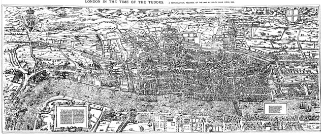
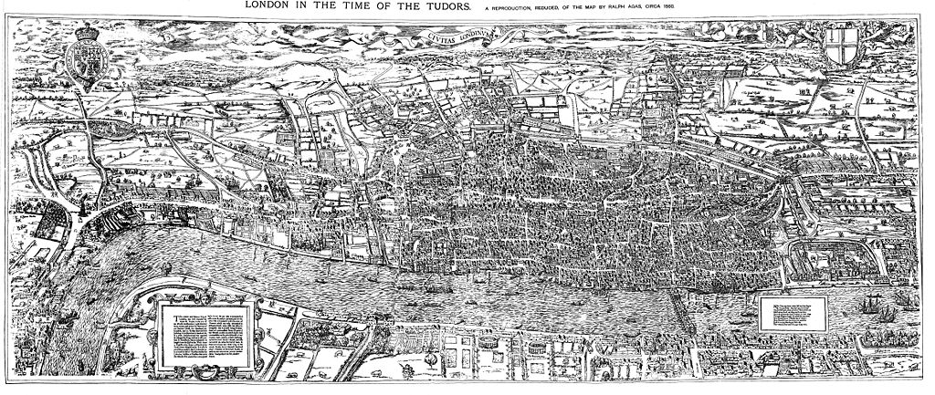
English: The earliest proper map (as opposed to panorama) of London known. Attributed to Ralph Agas, and probably surveyed between 1570 and 1605. The original was 6 foot 0.5 inches long by 2 feet 4.5 inches wide. This much reduced image is a scan of a copy of a lithograph of a copy, was itself badly repaired with sellotape and has had to be "restored"; so is hardly a truly faithful representation of the original, but few good copies exist and no other detailed public domain images are known. |
| Tarih | |
| Kaynak | Maps of Old London, London, Adam and Charles Black, 1908. Scanned & corrected Mike Calder. |
| Yazar | Mike Calder, image of Civitas Londinium, Agas' Map of London, c. 1570-1605 |
| Diğer sürümler | Bu dosyanın türev çalışmaları: Covent Garden from the Ralph Agas 1572 map of London.jpg |
Lisanslama
|
Bu çalışma ABD'de veya yazarın yaşamının sona ermiş olmasından 100 veya daha fazla süre geçtiğinde bu duruma uygun telif yasaları olan tüm ülkelerde kamu malıdır. | |
| Bu dosyanın, tüm ilgili ve komşu haklar da dâhil olmak üzere, telif hakkı yasası kapsamında bilinen kısıtlamalardan arınmış olduğu belirlendi. | |
Dosya geçmişi
Dosyanın herhangi bir zamandaki hâli için ilgili tarih/saat kısmına tıklayın.
| Tarih/Saat | Küçük resim | Boyutlar | Kullanıcı | Yorum | |
|---|---|---|---|---|---|
| güncel | 18.59, 14 Ağustos 2009 | | 4.730 × 2.000 (4,08 MB) | MikeCalder | {{Information |Description={{en|1=The earliest proper map (as opposed to panorama) of London known. Attributed to Ralph Agas, and probably surveyed between 1570 and 1605. The original was 6 foot 0.5 inches long by 2 feet 4.5 inches wide. This much reduc |
Dosya kullanımı
Bu görüntü dosyasına bağlantısı olan sayfalar:
Küresel dosya kullanımı
Aşağıdaki diğer vikiler bu dosyayı kullanır:
- af.wikipedia.org üzerinde kullanımı
- ar.wikipedia.org üzerinde kullanımı
- avk.wikipedia.org üzerinde kullanımı
- azb.wikipedia.org üzerinde kullanımı
- de.wikipedia.org üzerinde kullanımı
- el.wikipedia.org üzerinde kullanımı
- en.wikipedia.org üzerinde kullanımı
- es.wikipedia.org üzerinde kullanımı
- fa.wikipedia.org üzerinde kullanımı
- hy.wikipedia.org üzerinde kullanımı
- it.wikipedia.org üzerinde kullanımı
- ja.wikipedia.org üzerinde kullanımı
- ko.wikipedia.org üzerinde kullanımı
- la.wikipedia.org üzerinde kullanımı
- pt.wikipedia.org üzerinde kullanımı
- ro.wikipedia.org üzerinde kullanımı
- ru.wikipedia.org üzerinde kullanımı
- simple.wikipedia.org üzerinde kullanımı
- sl.wikipedia.org üzerinde kullanımı
- uk.wikipedia.org üzerinde kullanımı
- zh.wikipedia.org üzerinde kullanımı