Dosya:Communes of Luxembourg Highest.PNG
Daha yüksek çözünürlüğe sahip sürüm bulunmamaktadır.
Communes_of_Luxembourg_Highest.PNG ((203 × 270 piksel, dosya boyutu: 8 KB, MIME tipi: image/png))
Bu dosya Wikimedia Commons'ta bulunmaktadır. Dosyanın açıklaması aşağıda gösterilmiştir. Commons, serbest/özgür telifli medya dosyalarının bulundurulduğu depodur. Siz de yardım edebilirsiniz. |
Özet
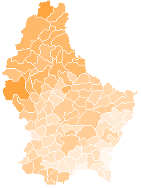
| Açıklama | A map of communes of Luxembourg after mergers of 2006-01-01, colour-coded by the altitude of the highest peak in the commune. The altitude is denoted by eight different shades of orange; in order of increasingly darker shades, the lower bounds (in m) are: 0, 300, 350, 375, 400, 450, 500, 550. |
| Tarih | |
| Kaynak | Own work based on Image:Communes of Luxembourg.PNG. |
| Yazar | User:Bastin8 |
| İzin (Bu dosyanın tekrar kullanımı) |
Released into the public domain. See licence below. |
Lisanslama
| Ben, bu işin telif sahibi, bu işi kamu malı olarak yayınlıyorum. Bu dünya çapında geçerlidir. Bazı ülkelerde bu yasal olarak mümkün olmayabilir; öyleyse: Ben, bu işi herhangi bir amaç için, herhangi bir şart olmaksızın, yasalarca gerekli olmadıkça, herkesin kullanmasına izin veriyorum. |
Dosya geçmişi
Dosyanın herhangi bir zamandaki hâli için ilgili tarih/saat kısmına tıklayın.
| Tarih/Saat | Küçük resim | Boyutlar | Kullanıcı | Yorum | |
|---|---|---|---|---|---|
| güncel | 15.28, 3 Mayıs 2006 | | 203 × 270 (8 KB) | Bastin8 | {{Information| |Description=A map of communes of Luxembourg after mergers of 2006-01-01, colour-coded by the altitude of the highest peak in the commune. The altitude is denoted by eight different shades of orange; in order of increasingly darker shades, |
Dosya kullanımı
Bu görüntü dosyasına bağlantısı olan sayfalar:
Küresel dosya kullanımı
Aşağıdaki diğer vikiler bu dosyayı kullanır:
- en.wikipedia.org üzerinde kullanımı
- es.wikipedia.org üzerinde kullanımı
- uk.wikipedia.org üzerinde kullanımı