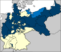
Dosya:Map-Prussia-Pomerania.svg

Bu SVG dosyasının PNG önizlemesinin boyutu: 706 × 599 piksel. Diğer çözünürlükler: 283 × 240 piksel | 566 × 480 piksel | 905 × 768 piksel | 1.207 × 1.024 piksel | 2.413 × 2.048 piksel | 2.592 × 2.200 piksel.
Tam çözünürlük (SVG dosyası, sözde 2.592 × 2.200 piksel, dosya boyutu: 754 KB)
Dosya geçmişi
Dosyanın herhangi bir zamandaki hâli için ilgili tarih/saat kısmına tıklayın.
| Tarih/Saat | Küçük resim | Boyutlar | Kullanıcı | Yorum | |
|---|---|---|---|---|---|
| güncel | 19.31, 23 Ocak 2007 |  | 2.592 × 2.200 (754 KB) | Conscious | Reverted to earlier revision |
| 19.31, 23 Ocak 2007 |  | 2.592 × 2.200 (625 KB) | Conscious | this version, uploaded on 24 December 2006, was licensed under cc-by-sa-2.5 by its author, en:User:52 Pickup | |
| 17.18, 13 Ocak 2007 |  | 2.592 × 2.200 (754 KB) | 52 Pickup | {{Information| |Description=The Prussian {{link|province of Pomerania}} (red), within the {{link|Kingdom of Prussia}} (blue). |Source= Based on map data of the IEG-Maps project (Andreas Kunz, B. Johnen and Joachim Robert Moeschl: University of Mainz) - h |
Dosya kullanımı
Bu görüntü dosyasına bağlantısı olan sayfalar:
Küresel dosya kullanımı
Aşağıdaki diğer vikiler bu dosyayı kullanır:
- da.wikipedia.org üzerinde kullanımı
- de.wikipedia.org üzerinde kullanımı
- en.wikipedia.org üzerinde kullanımı
- fr.wikipedia.org üzerinde kullanımı
- lt.wikipedia.org üzerinde kullanımı
- vi.wikipedia.org üzerinde kullanımı