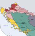
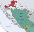
Dosya:Map of the Kingdom of Croatia (1868).png
Map_of_the_Kingdom_of_Croatia_(1868).png ((542 × 502 piksel, dosya boyutu: 40 KB, MIME tipi: image/png))
Dosya geçmişi
Dosyanın herhangi bir zamandaki hâli için ilgili tarih/saat kısmına tıklayın.
| Tarih/Saat | Küçük resim | Boyutlar | Kullanıcı | Yorum | |
|---|---|---|---|---|---|
| güncel | 18.35, 10 Kasım 2022 |  | 542 × 502 (40 KB) | CarRadovan | Reverted to version as of 22:47, 17 December 2016 (UTC) |
| 04.43, 12 Şubat 2017 |  | 542 × 552 (39 KB) | Ceha | Reverted to version as of 10:26, 17 December 2016 (UTC) as discussed before | |
| 22.47, 17 Aralık 2016 |  | 542 × 502 (40 KB) | Lilic | Reverted to version as of 11:51, 13 October 2009 (UTC) reverting to author's original map, as it is in fact better | |
| 10.26, 17 Aralık 2016 |  | 542 × 552 (39 KB) | Ceha | Showed croatian aspirations (pale orange), marked Slavonia as area which sended representatives in croatian parliament, as well as military borders which were part (at least in it's names) of Croatia and Slavonia. | |
| 11.51, 13 Ekim 2009 |  | 542 × 502 (40 KB) | DIREKTOR | {{Information |Description={{en|1=Map of the Kingdom of Croatia (red) in late 1867 and early 1868 (before the Croatian-Hungarian Nagodba and the establishment of the Kingdom of Croatia-Slavonia). The Kingdom of Slavonia was independent of Croatia at the t | |
| 11.49, 13 Ekim 2009 |  | 542 × 502 (40 KB) | DIREKTOR | {{Information |Description={{en|1=Map of the Kingdom of Croatia (red) in late 1867 and early 1868 (before the Croatian-Hungarian Nagodba and the establishment of the Kingdom of Croatia-Slavonia). The Kingdom of Slavonia was independent of Croatia at the t | |
| 11.45, 13 Ekim 2009 |  | 542 × 502 (40 KB) | DIREKTOR | {{Information |Description={{en|1=Map of the Kingdom of Croatia (red) in late 1867 and early 1868 (before the Croatian-Hungarian Nagodba and the establishment of the Kingdom of Croatia-Slavonia). The Kingdom of Slavonia was independent of Croatia at the t | |
| 10.04, 11 Ekim 2009 |  | 542 × 502 (39 KB) | DIREKTOR | {{Information |Description={{en|1=Map of the Kingdom of Croatia (red) in late 1867 and early 1868 (before the Croatian-Hungarian Nagodba and the establishment of the Kingdom of Croatia-Slavonia). The Kingdom of Slavonia was independent of Croatia at the t | |
| 16.39, 8 Ekim 2009 |  | 542 × 502 (38 KB) | DIREKTOR | {{Information |Description={{en|1=Map of the Kingdom of Croatia (red) in late 1867 and early 1868 (before the Croatian-Hungarian Nagodba and the establishment of the Kingdom of Croatia-Slavonia). The Kingdom of Slavonia was independent of Croatia at the t | |
| 12.47, 8 Ekim 2009 |  | 542 × 502 (38 KB) | DIREKTOR | {{Information |Description={{en|1=Map of the Kingdom of Croatia (red) in late 1867 and early 1868 (before the Croatian-Hungarian Nagodba and the establishment of the Kingdom of Croatia-Slavonia). The Kingdom of Slavonia was independent of Croatia at the t |
Dosya kullanımı
Bu görüntü dosyasına bağlantısı olan sayfalar:
Küresel dosya kullanımı
Aşağıdaki diğer vikiler bu dosyayı kullanır:
- azb.wikipedia.org üzerinde kullanımı
- bg.wikipedia.org üzerinde kullanımı
- bs.wikipedia.org üzerinde kullanımı
- cs.wikipedia.org üzerinde kullanımı
- el.wikipedia.org üzerinde kullanımı
- en.wikipedia.org üzerinde kullanımı
- es.wikipedia.org üzerinde kullanımı
- et.wikipedia.org üzerinde kullanımı
- eu.wikipedia.org üzerinde kullanımı
- fi.wikipedia.org üzerinde kullanımı
- hu.wikipedia.org üzerinde kullanımı
- it.wikipedia.org üzerinde kullanımı
- ja.wikipedia.org üzerinde kullanımı
- ko.wikipedia.org üzerinde kullanımı
- lv.wikipedia.org üzerinde kullanımı
- mk.wikipedia.org üzerinde kullanımı
- nl.wikipedia.org üzerinde kullanımı
- pt.wikipedia.org üzerinde kullanımı
- ro.wikipedia.org üzerinde kullanımı
- ru.wikipedia.org üzerinde kullanımı
- sh.wikipedia.org üzerinde kullanımı
- sl.wikipedia.org üzerinde kullanımı
- sr.wikipedia.org üzerinde kullanımı
- sv.wikipedia.org üzerinde kullanımı
- uk.wikipedia.org üzerinde kullanımı
- www.wikidata.org üzerinde kullanımı
