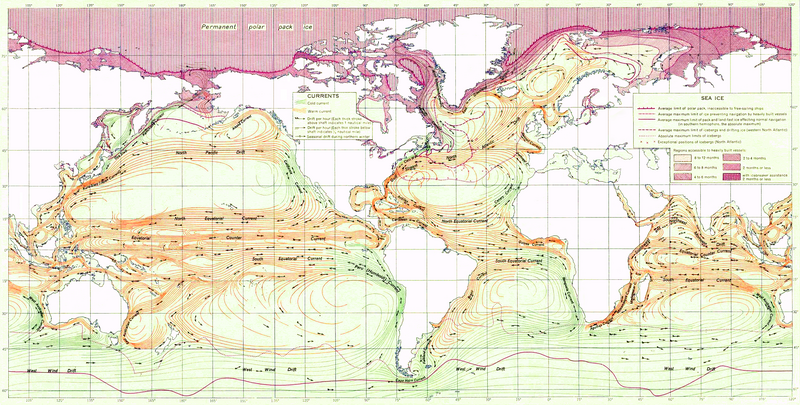
Dosya:Ocean currents 1943 (borderless)3.png

Bu önizlemenin boyutu: 800 × 405 piksel. Diğer çözünürlükler: 320 × 162 piksel | 640 × 324 piksel | 1.024 × 519 piksel | 1.280 × 649 piksel | 2.577 × 1.306 piksel.
Tam çözünürlük ((2.577 × 1.306 piksel, dosya boyutu: 2,41 MB, MIME tipi: image/png))
Dosya geçmişi
Dosyanın herhangi bir zamandaki hâli için ilgili tarih/saat kısmına tıklayın.
| Tarih/Saat | Küçük resim | Boyutlar | Kullanıcı | Yorum | |
|---|---|---|---|---|---|
| güncel | 21.18, 2 Şubat 2012 |  | 2.577 × 1.306 (2,41 MB) | Mahahahaneapneap | Compressed again. Please don't revert unless you can give a reason why. |
| 21.48, 19 Ocak 2012 |  | 2.577 × 1.306 (3,4 MB) | The ed17 | there is no reason to compress this | |
| 18.27, 24 Aralık 2011 |  | 2.577 × 1.306 (2,41 MB) | Mahahahaneapneap | Compressed. Identical image, 1 MB smaller. | |
| 14.34, 4 Eylül 2009 |  | 2.577 × 1.306 (3,4 MB) | Durova | Reverted to version as of 08:15, 27 June 2008 reverting arbitrary compression | |
| 20.54, 17 Ekim 2008 |  | 2.577 × 1.306 (2,41 MB) | Mahahahaneapneap | Compressed | |
| 08.15, 27 Haziran 2008 |  | 2.577 × 1.306 (3,4 MB) | Durova | {{Information |Description=''Ocean Currents and Sea Ice from Atlas of World Maps'', United States Army Service Forces, Army Specialized Training Division. Army Service Forces Manual M-101 (1943). |Source=http://www.lib.utexas.edu/maps/world_maps/ocean |
Dosya kullanımı
Bu görüntü dosyasına bağlantısı olan sayfalar:
Küresel dosya kullanımı
Aşağıdaki diğer vikiler bu dosyayı kullanır:
- ar.wikipedia.org üzerinde kullanımı
- ast.wikipedia.org üzerinde kullanımı
- az.wikipedia.org üzerinde kullanımı
- be.wikipedia.org üzerinde kullanımı
- bg.wikipedia.org üzerinde kullanımı
- bn.wikipedia.org üzerinde kullanımı
- ca.wikipedia.org üzerinde kullanımı
- da.wikipedia.org üzerinde kullanımı
- el.wikipedia.org üzerinde kullanımı
- en.wikipedia.org üzerinde kullanımı
- Ocean current
- Portal:Maps/Selected picture
- History of navigation
- Wikipedia:Featured pictures thumbs/12
- Wikipedia:Featured pictures/Diagrams, drawings, and maps/Maps
- User:Shoemaker's Holiday
- Wikipedia:Featured picture candidates/File:Ocean currents 1943 (borderless)3.png
- Wikipedia:Featured picture candidates/July-2008
- Wikipedia:Wikipedia Signpost/2008-07-07/Features and admins
- User talk:Durova/Archive 60
- Wikipedia:Wikipedia Signpost/2008-08-25/Features and admins
- Wikipedia:Wikipedia Signpost/2008-08-25/SPV
- Wikipedia:Wikipedia Signpost/2008-07-07/SPV
- Portal:Maps/Selected picture/37
- User talk:Shoemaker's Holiday/Archive 2
- Flow map
- Wikipedia:Picture of the day/January 2009
- Template:POTD/2009-01-05
- User talk:Durova/Archive 64
- User:Adam Cuerden
- User:Durova/Featured picture gallery/2008
- Wikipedia:WikiProject United States/Recognized content
- Wikipedia:WikiProject United States/Quality content
- Wikipedia:WikiProject United States/Featured pictures
- Wikipedia:Wikipedia Signpost/Single/2008-07-07
- Wikipedia:Wikipedia Signpost/Single/2008-08-25
- User:Coolmapseveryday/sandbox
- es.wikipedia.org üzerinde kullanımı
- fa.wikipedia.org üzerinde kullanımı
- hi.wikipedia.org üzerinde kullanımı
- hu.wikipedia.org üzerinde kullanımı
- ka.wikipedia.org üzerinde kullanımı
- lv.wikipedia.org üzerinde kullanımı
- mr.wikipedia.org üzerinde kullanımı
Bu dosyanın daha fazla küresel kullanımını görüntüle.


