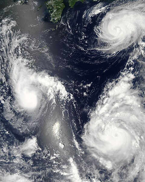
Dosya:Maria, Bopha and Saomai 2006-08-07 0435Z.jpg

Bu önizlemenin boyutu: 480 × 600 piksel. Diğer çözünürlükler: 192 × 240 piksel | 384 × 480 piksel | 614 × 768 piksel | 819 × 1.024 piksel | 1.638 × 2.048 piksel | 7.200 × 9.000 piksel.
Tam çözünürlük ((7.200 × 9.000 piksel, dosya boyutu: 7,6 MB, MIME tipi: image/jpeg))
Dosya geçmişi
Dosyanın herhangi bir zamandaki hâli için ilgili tarih/saat kısmına tıklayın.
| Tarih/Saat | Küçük resim | Boyutlar | Kullanıcı | Yorum | |
|---|---|---|---|---|---|
| güncel | 03.06, 8 Ağustos 2006 |  | 7.200 × 9.000 (7,6 MB) | Good kitty | == Summary == {{Information |Description=Three different typhoons were spinning over the western Pacific Ocean on August 7, 2006, when the Moderate Resolution Imaging Spectroradiometer (MODIS) on NASA’s Aqua satellite acquired this image. The strongest |
Dosya kullanımı
Bu görüntü dosyasına bağlantısı olan sayfalar:
Küresel dosya kullanımı
Aşağıdaki diğer vikiler bu dosyayı kullanır:
- ar.wikipedia.org üzerinde kullanımı
- az.wikipedia.org üzerinde kullanımı
- bg.wikipedia.org üzerinde kullanımı
- bh.wikipedia.org üzerinde kullanımı
- crh.wikipedia.org üzerinde kullanımı
- cs.wikipedia.org üzerinde kullanımı
- de.wikipedia.org üzerinde kullanımı
- en.wikipedia.org üzerinde kullanımı
- Typhoon
- Typhoon Saomai
- Tropical cyclone
- Wikipedia:Picture peer review/Archives/Archive2006
- User:Plasticup/MyFavorites
- Typhoon Maria (2006)
- User talk:Hurricanehink/Archive 23
- User talk:Thegreatdr/2012archive
- Wikipedia:Wikipedia Signpost/2013-11-20/Traffic report
- Wikipedia:Wikipedia Signpost/Single/2013-11-20
- Wikipedia:Top 25 Report/November 10 to 16, 2013
- User:Tfmbty/2006 Pacific typhoon season
- User:SongdaTalas/Archives of Former Articles
- en.wiktionary.org üzerinde kullanımı
- es.wikipedia.org üzerinde kullanımı
- fi.wikipedia.org üzerinde kullanımı
- hi.wikipedia.org üzerinde kullanımı
- id.wiktionary.org üzerinde kullanımı
- incubator.wikimedia.org üzerinde kullanımı
- ja.wikipedia.org üzerinde kullanımı
- ja.wikibooks.org üzerinde kullanımı
- ko.wikipedia.org üzerinde kullanımı
- lo.wikipedia.org üzerinde kullanımı
- ms.wikipedia.org üzerinde kullanımı
- my.wikipedia.org üzerinde kullanımı
- nn.wikipedia.org üzerinde kullanımı
- no.wikipedia.org üzerinde kullanımı
- pt.wikipedia.org üzerinde kullanımı
- ro.wikipedia.org üzerinde kullanımı
- ru.wikipedia.org üzerinde kullanımı
- szy.wikipedia.org üzerinde kullanımı
- th.wikipedia.org üzerinde kullanımı
- tk.wikipedia.org üzerinde kullanımı
- tt.wikipedia.org üzerinde kullanımı
Bu dosyanın daha fazla küresel kullanımını görüntüle.


