Dosya:UNGA Presidents from Eastern Europe.png

Bu önizlemenin boyutu: 800 × 581 piksel. Diğer çözünürlükler: 320 × 232 piksel | 640 × 465 piksel | 1.024 × 744 piksel | 1.280 × 930 piksel | 2.100 × 1.525 piksel.
Tam çözünürlük ((2.100 × 1.525 piksel, dosya boyutu: 105 KB, MIME tipi: image/png))
Bu dosya Wikimedia Commons'ta bulunmaktadır. Dosyanın açıklaması aşağıda gösterilmiştir. Commons, serbest/özgür telifli medya dosyalarının bulundurulduğu depodur. Siz de yardım edebilirsiniz. |
| Açıklama |
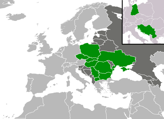
English: A map shoving from which countries from the en:Eastern European Group has there been elected a en:President of the United Nations General Assembly as of November 2017. |
| Tarih | (UTC) |
| Kaynak | |
| Yazar |
|
Bu dosya, Creative Commons Atıf-Benzer Paylaşım 3.0 Taşınmamış lisansı ile lisanslanmıştır
- Şu seçeneklerde özgürsünüz:
- paylaşım – eser paylaşımı, dağıtımı ve iletimi
- içeriği değiştirip uyarlama – eser adaptasyonu
- Aşağıdaki koşullar geçerli olacaktır:
- atıf – Esere yazar veya lisans sahibi tarafından belirtilen (ancak sizi ya da eseri kullanımınızı desteklediklerini ileri sürmeyecek bir) şekilde atıfta bulunmalısınız.
- benzer paylaşım – Maddeyi yeniden karıştırır, dönüştürür veya inşa ederseniz, katkılarınızı orijinal olarak aynı veya uyumlu lisans altında dağıtmanız gerekir.
Orijinal yükleme günlüğü
This image is a derivative work of the following images:
- File:BlankMap-Europe-v4.png licensed with Cc-by-sa-3.0-migrated, GFDL
- 2010-02-23T18:00:48Z Maps & Lucy 2100x1525 (131745 Bytes) Fixed the border of Kosovo with Serbia, proportioned British Overseas Cyprus Territories, San Marino, Vatican City, Monacco, and the Spanish Overseas Moroccan Territories, and added Guersney, Jersy, Liechtenstein, and Gibralt
- 2009-03-30T16:12:12Z Cradel 2100x1525 (131867 Bytes) Reverted to version as of 17:12, 8 March 2009
- 2009-03-20T22:20:11Z Avala 2100x1525 (70412 Bytes) what does this map represent? upload an alternative for unofficial views
- 2009-03-08T17:12:32Z Cradel 2100x1525 (131867 Bytes) Reverted to version as of 06:05, 5 April 2008
- 2008-11-20T01:00:56Z Tocino 2100x1525 (70412 Bytes) Reverted to version as of 19:36, 19 March 2008
- 2008-04-05T06:05:34Z Hoshie 2100x1525 (131867 Bytes) added the UK SBAs on Cyprus
- 2008-03-22T21:58:25Z Nightstallion 2100x1525 (131807 Bytes) Reverted to version as of 16:35, 13 March 2008
- 2008-03-19T19:36:48Z Patstuart 2100x1525 (70412 Bytes) Reverted to version as of 18:16, 11 March 2008 - see [[Image talk:BlankMap-World-v6.png#As stated in reversion]]
- 2008-03-13T16:35:26Z Nightstallion 2100x1525 (131807 Bytes) upload a variant if you wish, but the majority in Europe recognises or will recognise.
- 2008-03-11T18:16:50Z Avala 2100x1525 (70412 Bytes) there is no consensus in Europe
- 2008-02-24T02:42:03Z Hoshie 2100x1525 (131807 Bytes) Added Kosovo since it has been internationally recognized
- 2007-05-02T09:05:00Z Roke 2100x1525 (70412 Bytes) better version derived from svg
- 2006-06-26T06:32:12Z Roke 748x546 (27077 Bytes) minor - bottom left box
- 2006-06-26T05:53:48Z Roke 748x546 (27099 Bytes) {{Information |Description= blank map of europe, including north africa and western asia. With french overseas territories shown in inset lower left (French Guiana, Guadeloupe, Martinique, Reunion) |Source= derived from [[:Im
- File:BlankEurope1989.png licensed with Cc-by-sa-3.0-migrated, GFDL
- 2008-04-12T02:51:41Z Hoshie 1236x1245 (75613 Bytes) {{Information |Description=Blank map of Europe as of 31 December 1989 |Source=adapted from [[:Image:BlankEurope.png]]; FRG/GDR border is from [[:Image:NATO expansion.png]]. |Date=11 April 2008 |Author=made by ~~~. |Permission
Uploaded with derivativeFX
Dosya geçmişi
Dosyanın herhangi bir zamandaki hâli için ilgili tarih/saat kısmına tıklayın.
| Tarih/Saat | Küçük resim | Boyutlar | Kullanıcı | Yorum | |
|---|---|---|---|---|---|
| güncel | 20.03, 19 Kasım 2017 | | 2.100 × 1.525 (105 KB) | Forthrunner | Slovakia in 2017 |
| 18.48, 12 Eylül 2012 |  | 2.100 × 1.525 (146 KB) | Vanjagenije | Vuk Jeremic of Serbia was elected in 2012. | |
| 15.52, 29 Eylül 2010 |  | 2.100 × 1.525 (86 KB) | Mátyás | {{Information |Description=A map shoving from which countries from the Eastern European Group has there been elected a President of the United Nations General Assembly as of September 2010. |Source=*File:BlankMap-Europe-v4.png *[[:File:BlankEurope19 |
Dosya kullanımı
Bu görüntü dosyasına bağlantısı olan sayfalar:
Küresel dosya kullanımı
Aşağıdaki diğer vikiler bu dosyayı kullanır:
- ar.wikipedia.org üzerinde kullanımı
- en.wikipedia.org üzerinde kullanımı
- fr.wikipedia.org üzerinde kullanımı
- id.wikipedia.org üzerinde kullanımı